


The Original Miles-By-Motorcycle Group
established 11 years ago
You must be logged in and belong to this group to post to this forum.
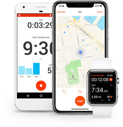
There are certainly things to learn here. What caught my eye first was the way they populated the metrics. That was cool and drew my attention to them.
I really think that metrics are going to stimulate a good portion of our demographic, no man can resist claiming his is bigger.
I really think that metrics are going to stimulate a good portion of our demographic, no man can resist claiming his is bigger.
Hi,
strava.com
fusar.com
Fusar incorporates an online community with a thumb-controlled bluetooth headset system interfaced with an app that facilitates in-ride social media posting, is a mapping and navigation tool, and serves as an in-ride communications hub.
Also check out EatSleepRide again. Theyve added a lot of features.
Shiny Side Up!☺
Thanks for adding -

FUSAR - Technology for People in Motion
FUSAR is the global leader in universal smart helmet technology. Download the App - track your ride. Smart tech for motorcycle and action sports enthusiasts.
http://fusar.com
Driftix
Driftix is a mobile application for bikers in the real world. We don t focus on likes, we focus on people. Bikers stick together and with that we want to help you.
https://www.driftix.com/
I recently did some testing of a few of the different moto navigation apps.
NaviRider: The "beta" navigation feature seems to work OK. It show on the screen the next turn and the distance to the next turn, but lack of audio cues sucks. Without audio cues, it's almost as useless as follow-the-line navigation.
It records your track while navigating you, which is nice. But once recorded, I don't see a way to export the track.
Rever: It is purely a "follow the line" navigator. Not even text for next turn or how far. You have to stare at the screen the whole time to not miss a turn, and no street names as guidance for which turn you want.
It can record your track, and you can import tracks or share tracks within the platform. Exporting a GPX and turn-by-turn directions are paid features. Requires a monthly subscription. I have not tested them yet.
Riser: Doesn't do navigation in the sense that I can't find a way to tell it what destination I want, but it can auto-generate some twisty ride plans that take you in a loop. Seems useful if you just want to go for a ride and don't really know/care where. I think it does record your track, but I'm not sure if the recorded track can be exported yet.
EatSleepRide: Does not appear to provide a route planning solution, just a track recorder. I haven't tested if the recorded track can be exported. I honestly don't see a lot of value to ESR.
The next question I plan to investigate is how best to navigate routes that I've planned here on M-By-MC. Yermo has given me some pointers on apps and techniques. I've also looked up a few others that I'd like to test. To start with: Maps.me, OsmAnd, OruxMaps.
One other nifty app I've found is Kampnik, which claims to list details on campsites across the country. On the Minneapolis trip I brought camping gear with me expecting to camp, but found that most of the campgrounds I could look up online were just as expensive as Motel 6, but with less amenities. So I didn't end up camping until the very last night of the trip before arriving home. Hopefully Kampnik can find me some cheaper camping spots.
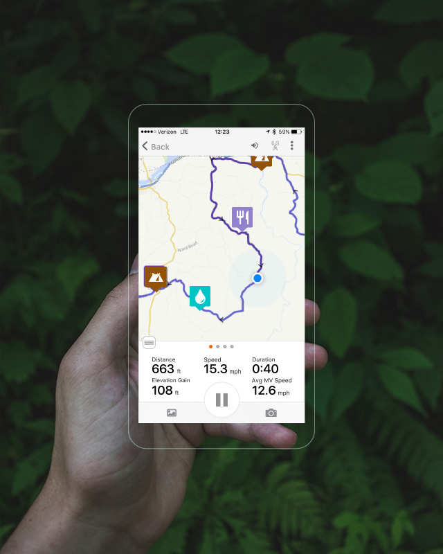
My old methodology was using mymaps.google.com for the brain storming and planning, then exporting route segments to Google Maps or Waze. I like that MyMaps allows you to import routes or tracks as separate layers, and to create/annotate points of interest. You can then enable Google Maps to overlay your MyMaps POIs and tracks on top of your Google Maps view. While you're in planning mode, the rich "places" database of Google Maps is helpful for finding potential stops in the vicinity of your route. You can also share and embed MyMaps maps.
For example, this was my planning map for the Minneapolis trip.
NaviRider: The "beta" navigation feature seems to work OK. It show on the screen the next turn and the distance to the next turn, but lack of audio cues sucks. Without audio cues, it's almost as useless as follow-the-line navigation.
It records your track while navigating you, which is nice. But once recorded, I don't see a way to export the track.
Rever: It is purely a "follow the line" navigator. Not even text for next turn or how far. You have to stare at the screen the whole time to not miss a turn, and no street names as guidance for which turn you want.
It can record your track, and you can import tracks or share tracks within the platform. Exporting a GPX and turn-by-turn directions are paid features. Requires a monthly subscription. I have not tested them yet.
Riser: Doesn't do navigation in the sense that I can't find a way to tell it what destination I want, but it can auto-generate some twisty ride plans that take you in a loop. Seems useful if you just want to go for a ride and don't really know/care where. I think it does record your track, but I'm not sure if the recorded track can be exported yet.
EatSleepRide: Does not appear to provide a route planning solution, just a track recorder. I haven't tested if the recorded track can be exported. I honestly don't see a lot of value to ESR.
The next question I plan to investigate is how best to navigate routes that I've planned here on M-By-MC.
Yermo has given me some pointers on apps and techniques. I've also looked up a few others that I'd like to test. To start with: Maps.me, OsmAnd, OruxMaps.One other nifty app I've found is Kampnik, which claims to list details on campsites across the country. On the Minneapolis trip I brought camping gear with me expecting to camp, but found that most of the campgrounds I could look up online were just as expensive as Motel 6, but with less amenities. So I didn't end up camping until the very last night of the trip before arriving home. Hopefully Kampnik can find me some cheaper camping spots.
My old methodology was using mymaps.google.com for the brain storming and planning, then exporting route segments to Google Maps or Waze. I like that MyMaps allows you to import routes or tracks as separate layers, and to create/annotate points of interest. You can then enable Google Maps to overlay your MyMaps POIs and tracks on top of your Google Maps view. While you're in planning mode, the rich "places" database of Google Maps is helpful for finding potential stops in the vicinity of your route. You can also share and embed MyMaps maps.
For example, this was my planning map for the Minneapolis trip.
I was working with  RubberChicken trying to come up with a way of integrating Google Maps with our routes here.
There's a new feature. Google Maps allows you 10 waypoints so now you can export 10 wayspoints at a time to google maps off the "routes" button on a map. There are two problems with this:
- you have to stop and load the next 10 waypoints each time.
- if you miss a waypoint Google Maps will continue to route you back to the one you missed. You can force it to bypass the missed waypoint but it's a multi-step process.
I have tried maps.me. The voice navigation works but so far it only says things like "Turn right in 1000 feet" but doesn't tell you the street name. With some practice it might work but I'm not sure.
My thought is that turn by turn directions/routing is just a "feature" so am looking for some app to integrate with. Sygic has turn by turn voice navigation and an API but it's a paid app. Scenic is also one to check out.
If we ever get to the point where we have enough funding, I'll look into licensing an on-phone turn by turn voice routing solution but it's not something that I could realistically develop on my own.
In other news, I am making some progress on recording tracks in the app. Geolocation on mobile devices is not nearly as straight forward as one would like it to be.
RubberChicken trying to come up with a way of integrating Google Maps with our routes here.There's a new feature. Google Maps allows you 10 waypoints so now you can export 10 wayspoints at a time to google maps off the "routes" button on a map. There are two problems with this:
- you have to stop and load the next 10 waypoints each time.
- if you miss a waypoint Google Maps will continue to route you back to the one you missed. You can force it to bypass the missed waypoint but it's a multi-step process.
I have tried maps.me. The voice navigation works but so far it only says things like "Turn right in 1000 feet" but doesn't tell you the street name. With some practice it might work but I'm not sure.
My thought is that turn by turn directions/routing is just a "feature" so am looking for some app to integrate with. Sygic has turn by turn voice navigation and an API but it's a paid app. Scenic is also one to check out.
If we ever get to the point where we have enough funding, I'll look into licensing an on-phone turn by turn voice routing solution but it's not something that I could realistically develop on my own.
In other news, I am making some progress on recording tracks in the app. Geolocation on mobile devices is not nearly as straight forward as one would like it to be.
Just this morning I received an email from Rever announcing some of their latest updates, including voice turn-by-turn directions. Unfortunately it's only available for iOS at this point. Once it's available on Android I'll probably give it a try.
But that does tell me that for now the feature doesn't exist (at least for Android users), so there's no point in me paying for the premium features until Android is supported.
But that does tell me that for now the feature doesn't exist (at least for Android users), so there's no point in me paying for the premium features until Android is supported.
Having an iPhone, I suspect I will have to check that out. Do you know if they support uploading/importing GPX routes and can properly follow them? That's the big problem with Google. It doesn't follow the route like a Garmin GPS would ...
They do support importing tracks/routes on the website, and the email suggested that they support importing in the app now as well. I haven't tested how well their routing works with imported tracks or routes.
I signed up for their premium version for a month to test it out.
Importing GPX routes into their app is buggy. Apparently, whoever wrote the route import code didn't understand the difference between a rtept and a wpt. If the turn by turn stuff works I'll have to make my GPX export bug compatible with their app.
However, importing GPX files to their website seems to work just fine. Other than downloading a GPX file generated from their site I haven't figured out how to get a route from the website into the app. There has to be some menu item somewhere.
Their route layout tool is confusing and busy.
I'll test the turn by turn directions in a bit. My initial impression is that it looks like it might work out ok.
Their app UI is super busy but it does look slick and it's pretty responsive.
The bad news is the turn by turn navigation in Rever suffers from the same problem that Google Maps does. If you miss a waypoint it will continue to try to route you back to the waypoint you missed even if you reach another waypoint. Then there doesn't seem to be any way to tell it to continue on to the next waypoint.
That's unfortunate, I guess Garmin is still the best option so far.
I also forgot to mention, I backed this Kickstarter.

It seems it's a motorcycle-specific variation on a device they originally decide for bicyclists.
I don't have super high hopes that they'll have a solution for these route-vs-track problems. However the minimalistic UX appealed to me.
To quote a Unix man page, "less is more, but more".
I also forgot to mention, I backed this Kickstarter.
Kickstarter >> Beeline Moto | smart navigation for motorcycles, made simple by Mark Jenner & Tom Putnam
Mark Jenner & Tom Putnam is raising funds for Beeline Moto | smart navigation for motorcycles, made simple on Kickstarter! Beautifully simple navigation, route planning and tracking for motorbikes, giving you the freedom to enjoy the ride
https://www.kickstarter.com/project...
It seems it's a motorcycle-specific variation on a device they originally decide for bicyclists.
I don't have super high hopes that they'll have a solution for these route-vs-track problems. However the minimalistic UX appealed to me.
To quote a Unix man page, "less is more, but more".
I've been seeing this occasionally -

Relive
Relive and share your outdoor adventures. With Relive, you can turn your activity into a legendary movie.
https://www.relive.cc/
Map Bike Rides with Elevation Profiles, Analyze Cycling Performance, Train Better. Ride With GPS
Ride with GPS creates tools that allow cyclists to plan, navigate, and share great rides. Using our website & app, riders can create detailed routes with cuesheets then navigate using turn-by-turn voice navigation or a GPS device.
https://ridewithgps.com/

Motorcycle Route Planner & GPS App | Harley-Davidson USA
The Harley-Davidson<sup> </sup> app is here and it s pure, unfiltered freedom in the palm of your hand. Get access to the best routes, stay on course with our real time GPS navigation, keep informed about up and coming events, and connect with fellow riders.
https://www.harley-davidson.com/us/...

Beeline Moto | Beeline
Smart navigation for motorcycles, made simple Pre-order As seen on Simple, safe navigation Beeline Moto s interface guides you in the clearest manner possible with one big arrow pointing in the direction you need to be heading right now. Simple! No complex instructions, no detailed maps. It s stripped back to the essen
https://beeline.co/pages/beeline-mo...
https://www.gpsies.com/
An unfortunate name. I know it has a long history in the motorcycle world, and is still used today by groups like the AMA, but there are many who see the term as an ethnic slur.
That their website equates the term with "vagabond" doesn't help.
I discovered that Riser does allow you to specify a destination address to navigate to, and you can configure the approximate length (in 30min intervals) of the ride you want. So Riser looks particularly interesting to me now, because of its "adventure routing" which finds "interesting" routes rather than efficient routes.
https://riserapp.com/
https://riserapp.com/
I'll have to check it out. Do they support GPX import?
And as far as navigation goes...
1. It does have turn-by-turn voice directions, but it seems like an immature implemenation
1a. The voice instructions are often late (not enough notice to make the turn, or even after the turn).
1b. Even though the visual directions show Imperial units, the voice directions use metric units.
1c. The distances given are always a whole number, but are always read as a float. For example, "in five *point* *zero* meters turn left". The extra "point zero" adds no useful information, wastes precious time, and just gets annoying.
2. The routing seems fragile. Rerouting doesn't always work, sometimes it just crashes the app.
3. It's slower than Google Maps/Waze at noticing when you've missed a turn. In fact, it seems like it generally has a less precise idea of where you actually are... which seems strange to me since isn't it just using Google Location Services?
4. When you have it generate a loop route for you, there's no indication of which direction the loop goes until you start riding it.
But as immature as the voice navigation is, it's still about as good as I've found so far from the motorcycle-specific navigation apps.
That said, I've only been playing with the free version, and haven't spent that much time in the app. One and a half trips so far. So it's possible that I just haven't figured out the settings I need to toggle or that it's better in the paid version.
I notice Rever just released new features (again) for iOS first. In most of these apps, Android seems like a second-class citizen.
At some point when I have free time again (and maybe a new bike to play with) I'll splurge on the paid versions and do some more thorough testing of these apps (both on their own and as companions to m-by-mc).

Maps & GPS Navigation OsmAnd+ - Apps on Google Play
OsmAnd+ (OSM Automated Navigation Directions) is a map and navigation application with access to the free, worldwide, and high-quality OpenStreetMap (OSM) data. Enjoy voice and optical navigation, viewing POIs (points of interest), creating and managing GPX tracks, using contour lines visualization and altitude info, a choice between driving, cycling, pedestrian modes, OSM editing and much more. OsmAnd+ is the paid application version. By buying it, you support the project, fund the development of new features, and receive the latest updates. Some of the main features: Navigation Works online (fast) or offline (no roaming charges when you are abroad) Turn-by-turn voice guidance (recorded and synthesized voices) Optional lane guidance, street name display, and estimated time of arrival Supports intermediate points on your itinerary Automatic re-routing whenever you deviate from the route Search for places by address, by type (e.g.: restaurant, hotel, gas station, museum), or by geographical coordinates Map Viewing Display your position and orientation Optionally align the picture according to compass or your direction of motion Save your most important places as Favorites Display POIs (point of interests) around you Display specialized online tiles, satellite view (from Bing), different overlays like touring/navigation GPX tracks and additional layers with customizable transparency Optionally display place names in English, local, or phonetic spelling Use OSM and Wikipedia Data High-quality information from the best collaborative projects of the world OSM data available per country or region Wikipedia POIs, great for sightseeing Unlimited free downloads, directly from the app Compact offline vector maps updated at least once a month Selection between complete region data and just road network (Example: All of Japan is 700 MB or 200 MB for the road network only) Safety Features Optional automated day/night view switching Optional speed limit display, with reminder if you exceed it Optional speed-dependent zooming Share your location so that your friends can find you Bicycle and Pedestrian Features Viewing foot, hiking, and bike paths, great for outdoor activities Special routing and display modes for bike and pedestrian Optional public transport stops (bus, tram, train) including line names Optional trip recording to local GPX file or online service Optional speed and altitude display Display of contour lines and hill-shading (via additional plugin) Directly Contribute to OSM Report data bugs Upload GPX tracks to OSM directly from the app Add POIs and directly upload them to OSM (or later if offline) Optional trip recording also in background mode (while device is in sleep mode) OsmAnd is open-source and actively being developed. Everyone can contribute to the application by reporting bugs, improving translations or coding new features. The project is in a lively state of continuous improvement by all these forms of developer and user interaction. The project progress also relies on financial contributions to fund coding and testing of new functionalities. Approximate map coverage and quality: Western Europe: **** Eastern Europe: *** Russia: *** North America: *** South America: ** Asia: ** Japan & Korea: *** Middle East: ** Africa: ** Antarctica: * Most countries around the globe available as downloads! From Afghanistan to Zimbabwe, from Australia to the USA. Argentina, Brazil, Canada, France, Germany, Mexico, UK, Spain, ...