
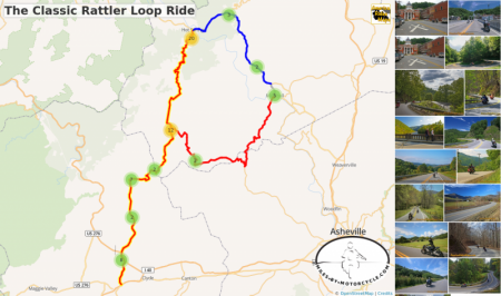
The Classic Rattler Loop Ride
This is the most common loop ride done with "The Rattler" - NC 209. It starts and ends at Junaluska covering about 100 miles. This is one of the best Blue Ridge Mountain riding experiences with mountain climbs, beautiful valleys, a nice mix of easy and challenging terrain, historic places and sights, lots of stops, and great scenery.
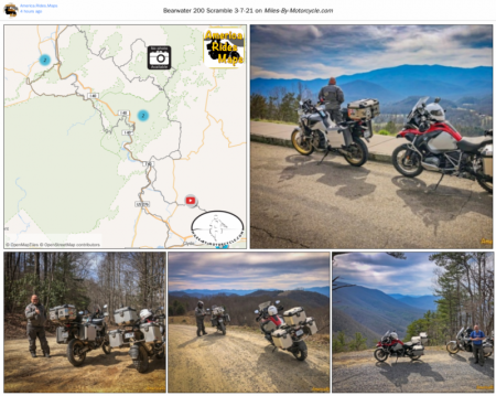
Bearwater 200 Scramble 3-7-21
This is a 137 mile loop ride based out of Bearwaters Brewery in Canton, NC. It runs north on some nice twisty paved roads, then enters the Pisgah National Forest on generally well maintained forest roads. It crosses into Tennessee, then loops back with sections that skirt Great Smoky Mountains National Park.

Wayah Rd
A classic ride out of Nantahala Gorge, Wayah Road climbs along the whitewater river up to Nathahala Lake, crusies along the top of the ridge, then plunges down the steep slopes to roll out across a valley. Loafer's Glory is a popular stop at the Franklin, NC end of the ride. There is a nice pulloff at the waterfalls on the climb up.
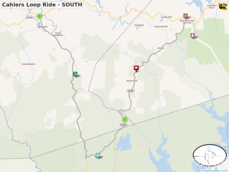
Cahiers Loop Ride - SOUTH
Wayne takes you on a 21 Mile long Motorcycle Ride looping south from Cashiers, North Carolina with 4 amazing and beautiful stops. This is a great ride to do when you visit the Land of the Waterfalls.
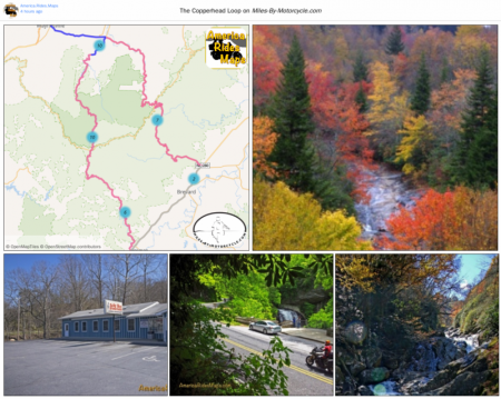
The Copperhead Loop
US 276 and NC 215 are two of the finest motorcycle rides you’ll find. The Copperhead Loop ride links them using US 64 through Brevard. You'll enjoy wonderfully twisty roads, waterfalls, and intersect the Blue Ridge Parkway at two points.
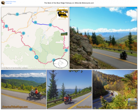
The Best of the Blue Ridge Parkway
This 43 mile section is the best of the 491 mile long ride. It's the highest, the most scenic and has more overlooks to enjoy it.
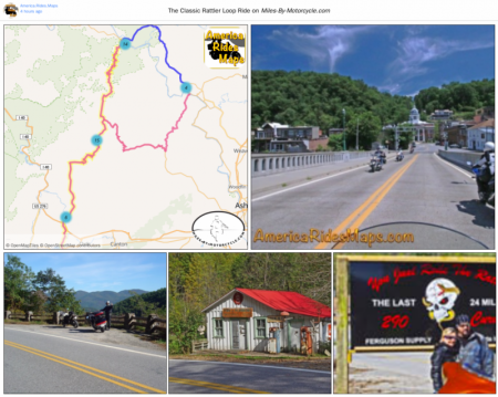
The Classic Rattler Loop Ride
This is the most common loop ride done with "The Rattler" - NC 209. It starts and ends at Junaluska covering about 100 miles. This is one of the best Blue Ridge Mountain riding experiences with mountain climbs, beautiful valleys, a nice mix of easy and challenging terrain, historic places and sights, lots of stops, and great scenery.
"There are more Great Motorcycle Rides in the Blue Ridge and Smoky Mountains than Anywhere Else!
Save with map
Best seller -
Southeast Blue Ridge Map Package | America Rides Maps
Full Southeast Package, motorcycle maps, motorcycle touring, touring the blue ridge, ride the Blue Ridge Parkway, best motorcycle rides
All 13 Motorcycle Ride Pocket Maps | America Rides Maps
All current pocket maps - paved and unpaved roads. If you're looking for adventure, you'll find it here.
Motorcycle Rides surrounding Great Smoky Mountains National Park | America Rides Maps
Motorcycle Rides surrounding Great Smoky Mountains National Park maps, motorcycle smoky mountains, great rides near Great Smoky Mountains, Best motorcycle rides
3 pocket maps combined
100 Rides in the Southern Blue Ridge | America Rides Maps
A comprehensive map of all the great motorcycle rides at the south end of the Blue Ridge mountains.
3 Map Smoky Park Unpaved Set | America Rides Maps
The unpaved roads in and surrounding Great Smoky Mountains National Park
Great Rides Near the Start of the Blue Ridge Parkway | America Rides Maps
Motorcycle rides in Virginia, Virginia Ride Maps, Ride the Blue Ridge Parkway, Virginia Motorcycle roads, Motorcycle tour Virginia
#2 The Roads Of Roanoke and Beyond | America Rides Maps
The Best Roads near Roanoke, Virginia
North Carolina / Virginia Border Rides | America Rides Maps
North Carolina Motorcycle Rides, Virginia Motorcycle Rides Rides, Ride the Blue Ridge Parkway, motorcycle touring Virginia, motorcycle touring North Carolina, Best motorcycle rides
#4 Great Roads Near Boone, Banner Elk, and Blowing Rock | America Rides Maps
All the best roads where the mountains really get big in North Carolina
#5 The Best Rides North and South of Asheville, NC | America Rides Maps
Home to the highest mountains in the east and some of the best rides
#6 The Best Motorcycle Rides Near Smoky Mountains Park - EAST | America Rides Maps
East and south of the Smoky Mountains, the land of the Waterfalls.
#7 The Best Motorcycle Rides Near Smoky Park - SOUTH | America Rides Maps
South and west of the Smoky Mountains, Waterfalls, The Dragon, and some of the best riding.
Best Rides NORTH of Smoky Park | America Rides Maps
Rides on the North side of the Smoky Mountains around Gatlinburg, Pigeon Forge, an the surroundings.